400万人が利用するビジネスSNS

百束 泰俊
◼️2019 - Present Established Tenchijin, Inc. Co-founder/COO ◼️2004 - Present Joined Japan Aerospace Exploration Agency (JAXA). Development of Global Precipitation Measurement (GPM core satellite) Development of Greenhouse Gases Observing Satellite 2 (Ibuki-2)
桜庭 康人
2019, President of Tenjijin Inc. 2016, at SenSprout Inc, be in charge of web, app development and service management. 2010, at MINDSCOPE Inc. as a new business plan and director for Mobatsui. 2012, at XTONE Inc. as a service development producer and new development LAB leader.
浦部雄平
株式会社天地人のメンバー
なにをやっているのか


なにをやっているのか
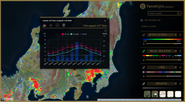
Land Evaluation Monitoring Service Using Satellite Data and AI
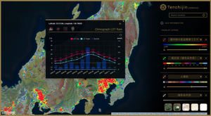
It allows to use the latest satellite and meteorological data, as well as a vast amount of other data, in MAP format without specialized knowledge, and an API linking service that makes it easy to add value to customer services with space big data.
なぜやるのか

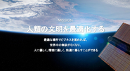
Our mission: Optimize Human Civilization by "Space Big Data"

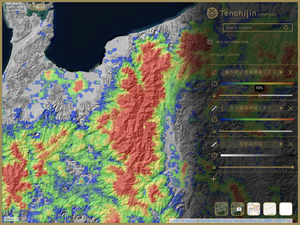
We've been getting a lot of inquiries about the Space Big Data Rice Project, which aims to produce a brand of rice that can cope with climate change, and we'll be selling the rice soon!
どうやっているのか

We work remotely and in a friendly atmosphere.

We have a workspace in X-NIHONBASHI, a place where space startups gather near Nihonbashi. It's cool!
こんなことやります
会社の注目のストーリー
株式会社天地人の他の募集
- リードリサーチャー
各分野で経験を積んだ専門性の高いエキスパートたちとともに、価値を創出
- プロジェクトマネージャー
各分野で経験を積んだ専門性の高いエキスパートたちとともに、価値を創出
- AI/Object Detec
各分野で経験を積んだ専門性の高いエキスパートたちとともに、価値を創出
0人がこの募集を応援しています
話を聞きに行くステップ
- 応募する「話を聞きに行きたい」から応募
- 会社からの返信を待つ
- 話す日程を決める
- 話を聞きに行く
会社情報
2019/05に設立
83人のメンバー
- 1億円以上の資金を調達済み/
- 海外進出している/
1-1-1, Shibakoen, Minatoku, Tokyo 9F Sumitomo Fudosan Onarimon Tower